 |
| Three of the 27 radio antennas in a Y-shaped configuration on the Plains of San Agustin, fifty miles west of Socorro, New Mexico |
 |
| The Salt River near the bottom of the Salt River Canyon |
 |
| Susan with her Aunt Lois |
 |
| Mike, with Lois at her fancy keyboard |
We did something new this trip and attended the evening Dark Sky Discovery program at Kitt Peak Observatory. On our way there, we went through Saguaro National Park (west) just for fun.


Kitt Peak is a very interesting place and after dark no lights are allowed anywhere on the mountain. We were not even allowed to use our phones or cameras because even the led screens could interfere with the sensitive telescopes.
 |
| Observatories on the summit of Kitt Peak |

 |
| Just after sunset and before our Dark Sky program began |
While waiting for darkness, our volunteer astronomer guide gave us a lot information about the observatory, the night sky, and the celestial objects we would be observing through our group's mini-observatory.
 |
| The small observatory our group/tour was on for the evening |
 |
| The "small" computer controlled telescope we used that night |
After the program, we followed a pilot car back down the mountain, our headlights having been covered with red plastic before it got dark.

From Tucson we headed to Chiricahua National Monument a couple hours away.
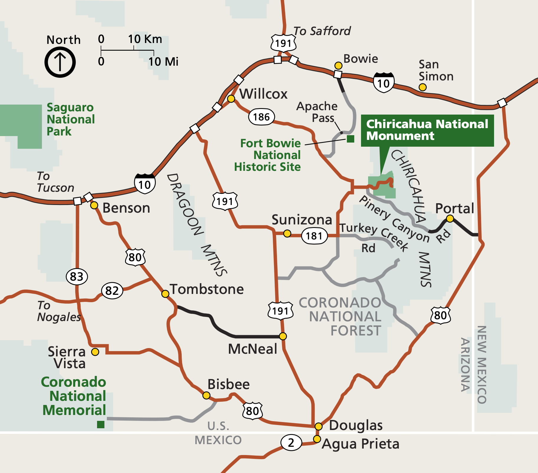
We checked in at the visitor center and made our hiking plan for the next day. Then we drove the Bonita Canyon Scenic Road and hiked the short nature trail around Massai Point.
 |

In the morning we parked our car at the visitors center and took the hikers shuttle to Echo Canyon Trailhead. We followed the trail past Echo Canyon Grotto, all the way to the junction with the Hailstone Trail where we headed back east.

Next was the Mushroom Rock Trail where we had the majority of our elevation gain and hit some ice and snow. Another mile west along the Big Balanced Rock Trail and we were surrounded by rock monoliths. We made a great lunch spot atop one of them.


The Heart of the Rocks loop was quite icy in spots, but we made our way through this famous part of the Monument without falling!
 |
| River of ice on the trail! |
 |
| Susan hiking down into Heart of the Rocks |

The last two miles along the Sarah Deming Trail and Lower Rhyolite Canyon Trail were a relatively easy end to our ~9 mile hike. We especially enjoyed hiking out with the steep Rhyolite Canyon wall to our right in the late afternoon light.
 |
| Balanced Rock |

We stayed at the nearby Dreamcatcher B&B for two nights where we enjoyed fancy 5 course dinners each night and hearty breakfasts each morning. The night of our big hike happened to be the Inn's 20th anniversary so there was some extra celebrating and Baked Alaska.
In the morning we said goodbye to the Chiricahuas and made a birdwatching stop at Whitewater Draw Wildlife Area to see the Sandhill Cranes fly in shortly before noon. This is a wonderful out of the way birding location, although we were too early in the season to see migrant species.
In the morning we said goodbye to the Chiricahuas and made a birdwatching stop at Whitewater Draw Wildlife Area to see the Sandhill Cranes fly in shortly before noon. This is a wonderful out of the way birding location, although we were too early in the season to see migrant species.
 |
| One of several bodies of water at Whitewater Draw |
 |
| Sandhill Cranes filling the sky! |
 |
| Sandhills coming in to roost |
 |
There were a hundred or so cranes when we first arrived, but soon they started arriving in great numbers. We had never seen so many in flight at this time of day. It was quite a show!
We drove on to for a late lunch at the Bisbee Queen Hotel where we had the best French dip sandwiches ever! We made a brief stop to look down into the nearby copper mine quarry.

We continued to our hotel in Sierra Vista via Tombstone, which was a a little touristy for our taste. After we walked the main street, and checked out Boothill Graveyard, we drove on to Sierra Vista.
 |
| Main Street Tombstone |
 |
| Tombstone Courthouse |

 |
| Boothill Graveyard |
Next, we decided to head south to Coronado National Memorial which sits on the Mexican border. We drove up the winding road to Montezuma Pass and walked out to the summit of Coronado Peak.
 |
| The road coming up to the summit of Coronado Peak |
 |
| View from the summit |
The next morning we walked birding trails along the San Pedro River from San Pedro House before heading back to Willcox, AZ for the night.
 |
| Gila Woodpecker (Melanerpes uropygialis) observed near the San Pedro River |
We hoped to see more Sandhills near Willcox, as we had noticed them circling above Twin Lakes on our way to the Chirichauas. We weren't disappointed!

 |
| Sandhills going down for the night near Willcox, AZ |
We were fortunate to have a beautiful sunset to watch them come in to roost. We also saw the largest flock of Yellow-headed Blackbirds we'd ever seen.


We decided we would come back to southeast Arizona for birdwatching later in the year, and the next morning headed north via very scenic Route 191 all the way to Blanding, UT. It was a long day in the car, but well worth the time.

 |
| Along Highway 191 |
I guess we had forgotten about winter and were surprised to see so much snow around Blanding. The trail and road conditions changed our plans and we stayed just two nights. In Natural Bridges National Monument, we were unable to do the 8 mile canyon hike to all three bridges due to ice and river crossings, but had a nice walk nevertheless.
 |
| Snow Natural Bridges National Monument |
 |
| Overview of the canyons at Natural Bridges |
 |
| Owachomo Bridge |
 |
| Susan on the other side of Owachomo Bridge |
 |
| Our hike through Owachomo Bridge down into Tuwa Canyon. We had to turn around due to too much ice and snow. |
In the afternoon we hiked into Mule Canyon, part of the new Bears Ears National Monument. We stopped at the Mule Canyon Ruin, an Anasazi site just off the main road, before hitting the trail.

 |
| Mule Canyon Ruin |
 |
| The Kiva at the Mule Canyon Ruin |
We hiked in as far as the first ruins, "House on Fire." It was an easy 1.2 miles each way of mostly flat hiking, though there was water, snow and ice on the trail. We were happy to have our trekking poles and microspikes. There were no other people hiking that day and we relished the solitude and beauty of the canyon.
 |
| Map/track of our hike to House on Fire |
 |
| Our snowy parking space at the start of the hike into Mule Canyon |
 |
| Susan, on the trail, such as it was |
 |
| The complete site at House on Fire |
 |
| Easy to see how "House on Fire" got its name |
 |
| We hiked just around the bend from House on Fire but were running out of daylight, so reluctantly turned around. |
With a winter storm warning in Summit County, we decided to leave early the next morning for home. It was a really fun trip, and as frequently happens, we discovered as many new things to add to our list as we checked off.


